top of page

Our Projects
 Small Topographic MapA small-sized topographic map located at Hawaii Kai, Oahu, Hawai'i. |  Medium-sized Topographic MapA medium sized topographic map (sheet 1 of 4) of Kaneohe Marine Corps Base in Kailua, Oahu, Hawai'i. Overlayed with aerial photography. |  Large Topographic SurveyA large sized topographic map (sheet 1 of 7) located in Ewa, Oahu, Hawai'i. |
|---|---|---|
 Roadway Topographic MapA comprehensive roadway topographic map including subsurface and overhead utilities. |  Real Estate (K2) Perimeter SketchA real estate (Item K.2.) Perimeter Sketch Map located at Palolo, Oahu, Hawai'i. |  Real Estate Survey ReportA real estate (Item K.2.) Perimeter Sketch Report corresponding to preceding Perimeter Sketch Map. |
 Site Construction StakeoutA proposed construction layout relocating McKinley High School's track-and-field facilities located at Honolulu, Oahu, Hawai'i. |  Construction Cut SheetA graphical staking Cut Sheet of the preceding McKinley High School track-and-field site. | 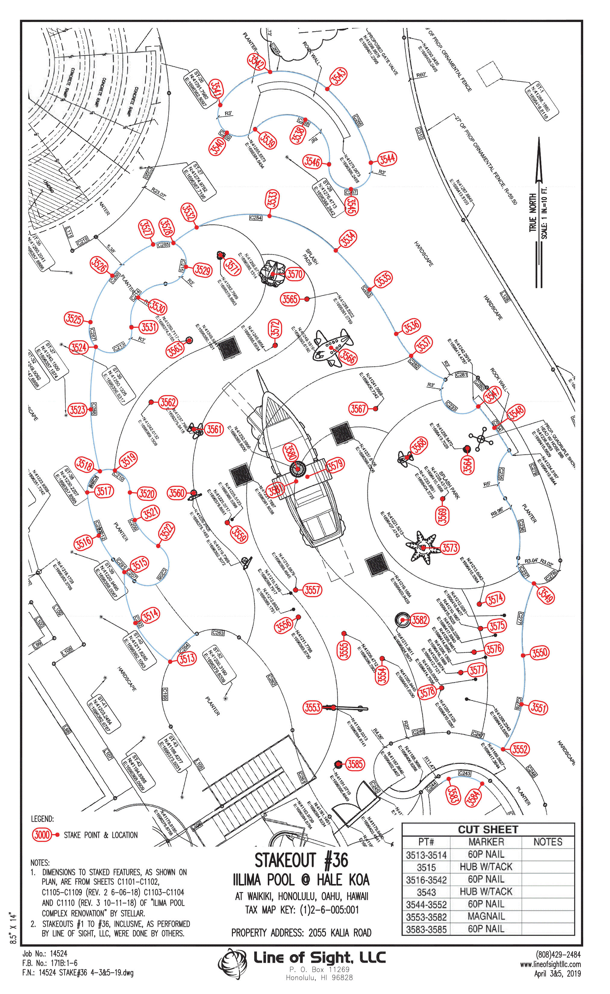 Construction Cut SheetA graphical staking Cut Sheet of "Actual" points for Hale Koa Hotel Ilima Pool site. |
 Utility Construction Cut SheetA graphical construction staking Cut Sheet showing proposed water line installations at various locations around Oahu, Hawai'i. |  Utility Construction Cut SheetA long form construction staking Cut Sheet showing proposed water line installations at various locations that accompanies the previous graphical Cut Sheet. |  Subdivision Map (Land Court)A map of a subdivision within the Land Court land tenure system. Located in Kula, Maui, Hawai'i. |
 Subdivision Map (Regular System)Subdivision Map done in Kailua, Maui, Hawai'i. |  Legal Description of LotA standard Legal Description of a privately owned lot corresponding to the previous subdivision map. |  Legal Description of Road DedicationA legal description depicting a roadway lot to be dedicated to the County corresponding to the previous subdivision map. This description is formatted to satisfy County description writing standards. |
 ALTA/ACSM Land Title SurveyAn ALTA survey partially overlayed with aerial photography. Property located in He'eia, Oahu, Hawai'i. |  ALTA/ACSM Survey MapThis ALTA map shows client specific requirements and the formatting and "look" of the map is different in comparison with the previous ALTA map. Line of Sight will always cater to the needs of our clients. |  Lot CertificationA Lot Certification is for verification of property boundaries for for a property about to be staked by LOS. CPR, subdivisions and Shoreline Certifications are verified by Lot Certification before commencement of a project. Lot Certifications are also used by property owners to contest the current location of their boundary markers. |
 Stakeout following a Lot Cert.Lot Certifications are usually done by Line of Sight prior to Construction Staking, CPR's, subdividing and Shoreline Certifications. |  CRP MapCondominium Property Regime (CPR) Map. An alternative way of dividing property opposed to a County approved Subdivision. |  Land Use Boundary MapLand Use Boundary Map depicting the dividing line between Conservation and Urban Boundaries. |
 Shoreline Certification MapA shoreline certification map for the purposes of identifying the "Shoreline" which has to be according to the State of Hawaii DAGS & OCCL guidelines. A certification is required for building permit purposes for oceanfront properties. |  High Accuract CertificationA Certification of a digester tank. A series of redundant checks were done taking shots along the same vertical line at 3 different elevations at equal distances. |  Stockpile Volume Topographc MapA topographic survey map along with stockpile volume calculations and methodology report. |
 Mitigated CPR MapA recalculated Condominium Property Regime (CPR) map. Mitigation by Line of Sight is shown in red while the original erroneous data (by others) is shown in black. | 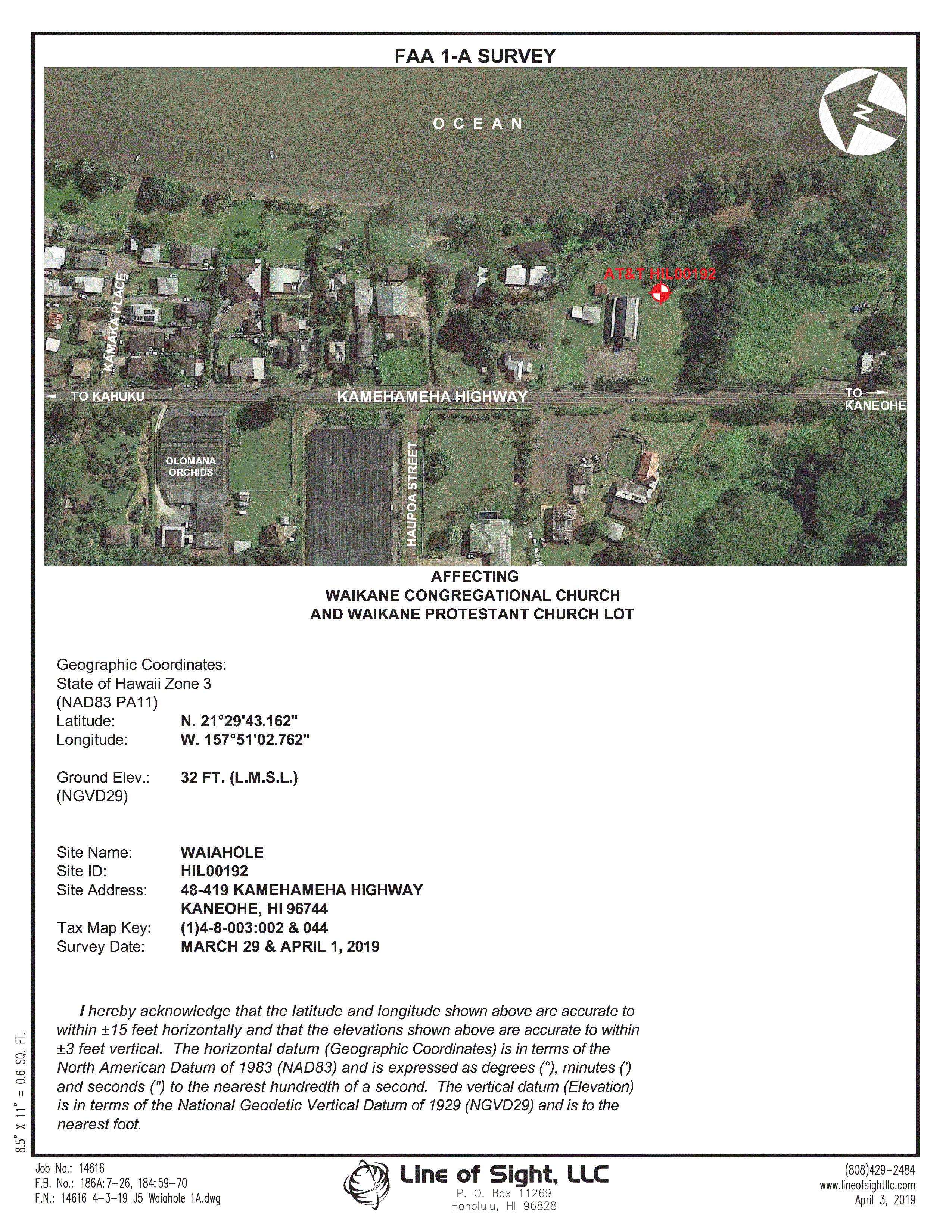 FAA 1-A FormFederal Aviation Administration form 1-A showing the location of a proposed site in Waiahole, Oahu | 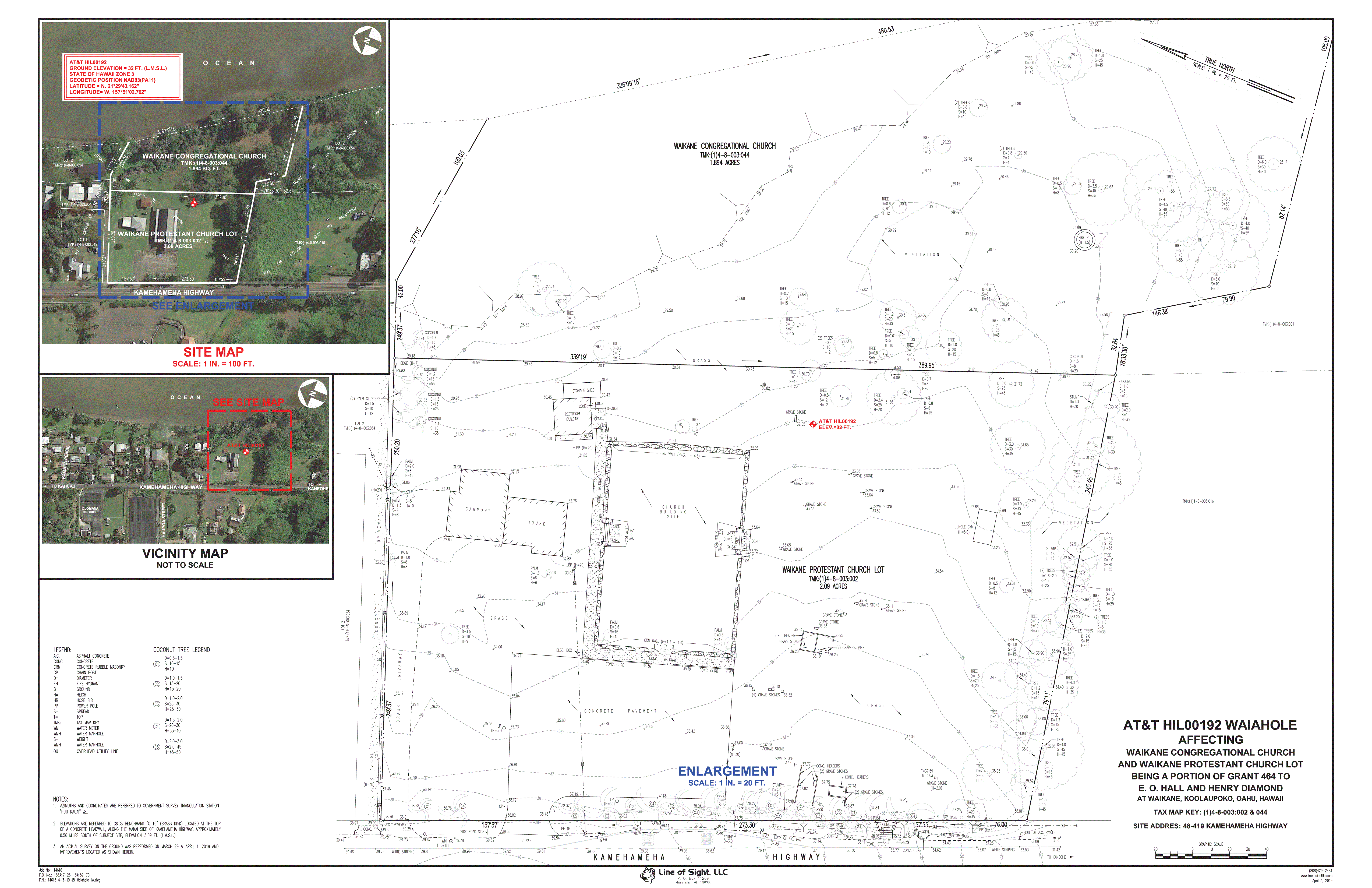 FAA 1-A Topographic MapFederal Aviation Administration Topographic Map for design & planning purposes of a proposed site in Waiahole, Oahu |
 NEPA Compliance ChecklistNEPA Checklist for an existing communications tower. |  Elevation Floodproofing Cert.A FEMA Elevation Floodproofing Certification is to provide a property owner with an elevation relative to Mean Sea Level as endorsed by FEMA. |  Boundary MapSpecific Boundary Determination specific to County assets relative to Roadway Right-of-Way |
 Surface Monitoring Map & AnalysisSurface Monitoring of a Pier of the Pearl Harbor Naval Facility. |  Surface Monitoring AnalysisClose-up of the previous Pearl Harbor Naval Facility. |  Boundary DeterminatonBoundary Determinations: LOS will prepare a determination map which includes our standard map & report and also including associated control network, equipment used and field procedures. |
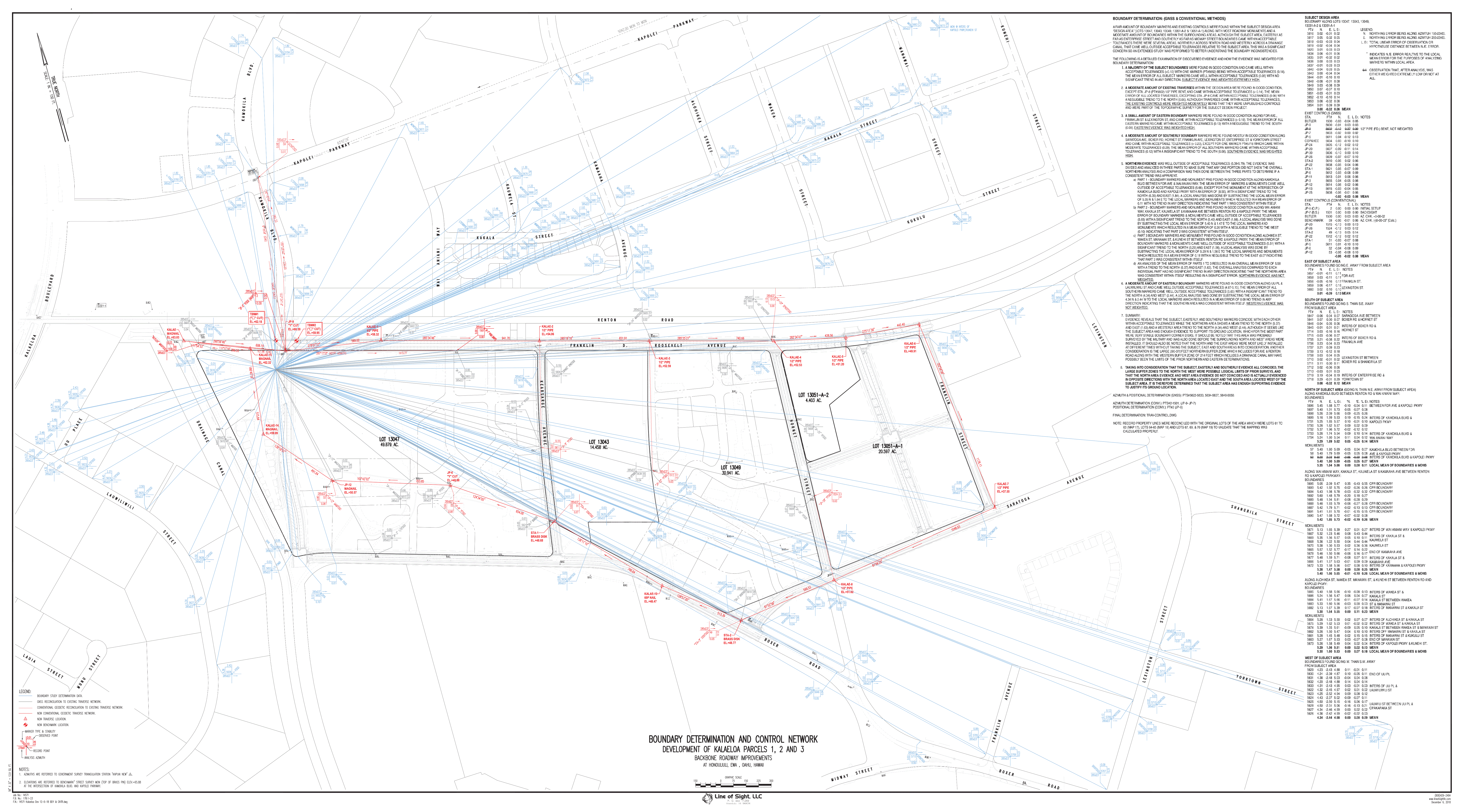 Comprehensive Boundary DeterminationComprehensive Boundary Determinations: LOS will prepare a comprehensive map including calculations, methodology and our standard map & report and including associated control network, equipment used and field procedures. |
bottom of page